COMOS Walkinside Builder
Creating a complete 3D virtual model of a plant
Description
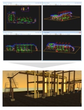
The COMOS Walkinside Builder automatically creates a complete 3D virtual model of the largest industrial process plants by merging native files from diverse data sources and proprietary formats.
It automatically reads information on geometry, CAD hierarchy, engineering database and textures during the conversion process from the various CAD files. Therefore, initial 3D model creation and subsequent updates are uniquely easy, fast and convenient, using the COMOS Walkinside converters.
Benefits
- Easy to use
- Highly realistic visualization
- Fast and convenient creation of the complete 3D VR model
- Unique and efficient handling of largest data volumesText
Design and function
The COMOS Walkinside Builder accepts Review Reality File format files from AVEVA, for example, for geometry information and attributes files for database information. It also supports numerous main file formats. The resulting unified virtual 3D model can also incorporate aerial photography and digital terrain models (DTM). Walkinside automatically and rapidly converts all geometric data into interactive 3D walkthroughs for quality control, accessibility and safety review, using the COMOS Walkinside Viewer.
It also contains the option to create “Automatic batch exports” which facilitate regular updates of the model. Mapping of textures to the plant model helps adding realism to the virtual world by generating an immersive model of the site that is more similar to the look and feel of the ‘as-built’ status of the plant.
The COMOS Walkinside SURF Builder (for Seabed, Umbilicals, Raisers and Flowlines) enables users to build a single unified model combining the 3D VR models and engineering data bases of the topside infrastructure, such as FPSO, Platforms, turrets, etc. with all the subsea equipment. The SURF Builder creates a virtual digital terrain from the subsea survey data. The subsea field layout is produced directly from the GIS data (Geographical Information System) and includes the position of flow lines, service lines, as well as the positions of equipment, anchor base and riser base.
Security information
To ensure the secure operation of a plant or machine it is also necessary to take suitable preventive action (e.g. cell protection concept) and to integrate the automation and drive components into a state-of-the-art holistic industrial security concept for the entire plant or machine. Any third-party products that may be in use must also be taken into account.